In this post, we are going to show you some maps of Bahia that will help you to get to know this territory of Bahia better, which is so culturally and geographically diverse.
The state of Bahia is part of the northeast region. It occupies an area of 564,722.611 km², which corresponds to about 6.6% of the national territory. It is the fifth largest state in Brazil in terms of territory, behind only Amazonas, Pará, Mato Grosso and Minas Gerais. It also has the longest coastline in the country, which has paradises such as Costa do Sauípe, Barra do Jacuípe and natural pools along the entire coast and seafront, with the sea meeting the river in many of these points.
The capital is Salvador, which was the first capital of Brazil and is considered one of the main historical and cultural centers of the country. Other important cities are Feira de Santana, Lauro de Freitas, Vitória da Conquista, Camaçari, Itabuna, Juazeiro and Barreiras.
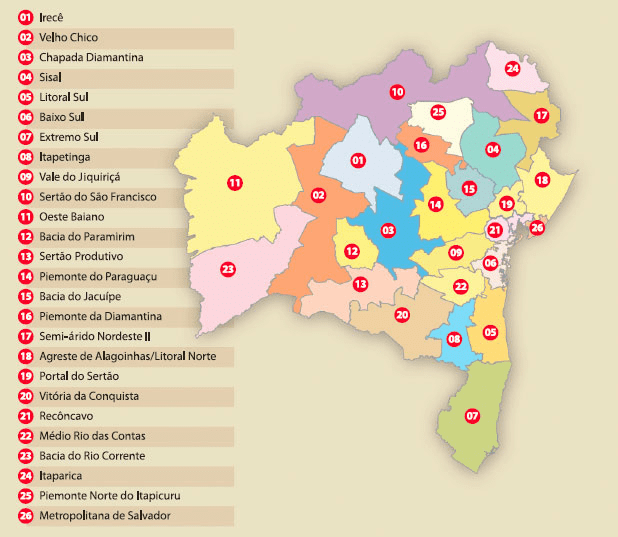
bahia identity territories map
Bahia is divided into 417 municipalities, which are grouped into 27 identity territories. These territories are defined by the state government based on criteria such as geographic, economic, social and cultural characteristics of the regions. Identity territories aim to facilitate the planning and execution of public policies that meet the specific needs of each area. This is Bahia's identity map.
Next, we will present some maps of Bahia that illustrate the different dimensions of this wonderful state.
Bahia political map (Map of municipalities in Bahia)
The political map of Bahia shows the division of municipalities and their respective seats. It also indicates the highways that cross the state and the main cities.
Source: IBGE
Bahia tourist map (Map of Bahia with tourist cities)
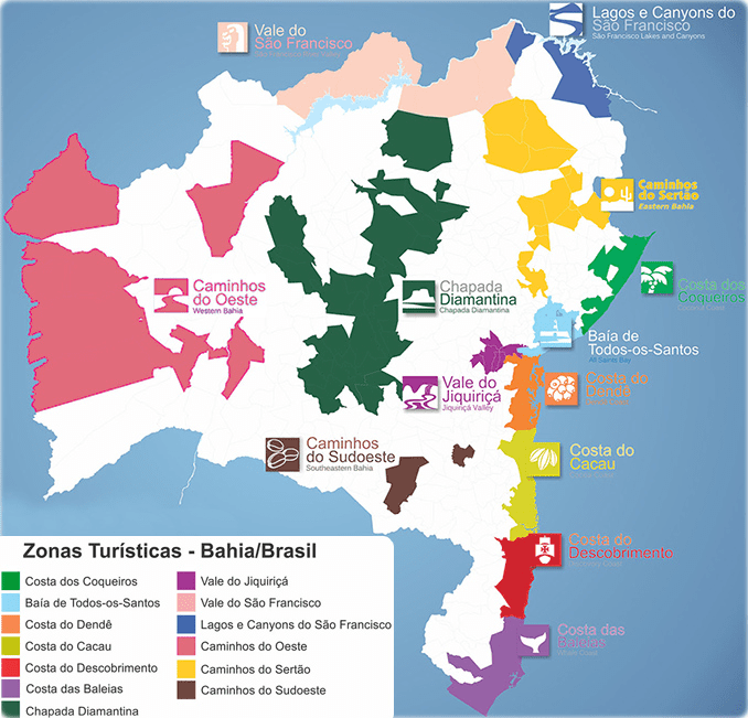
The tourist map of Bahia highlights the 13 tourist zones in the state, which are:
– Caminhos do Oeste is the region of Oeste Baiano. This region stands out for its agricultural production. It is also known for ecotourism in the Chapada Diamantina National Park.
– Caminhos do Sertão: covers the municipalities of the sertão of Bahia, which preserve the culture and history of cowboys and cangaceiros.
– Caminhos do Sudoeste: covers the municipalities in the southwest of Bahia, which offer natural attractions such as waterfalls, caves and rivers.
– Caminhos do Jiquiriçá: covers the municipalities of the Jiquiriçá valley, whose main attractions are popular festivals and cultural manifestations.
– Chapada Diamantina: covers several municipalities in the region. It is one of the main ecotourism destinations in Brazil, with stunning landscapes and several adventure options.
– Costa das Baleias: covers the municipalities in the extreme south of Bahia, which are characterized by beautiful beaches and the observation of humpback whales.
– Costa do Cocoa: covers the municipalities of southern Bahia. They stand out for their cocoa production and the presence of Atlantic Forest reserves.
– Costa do Dendê: covers the municipalities of the lower south of Bahia, whose main attractions are paradisiacal beaches and tropical islands.
– Costa do Descobrimento: covers the municipalities on the south coast of Bahia. They are marked by the history of the discovery of Brazil and cultural diversity.
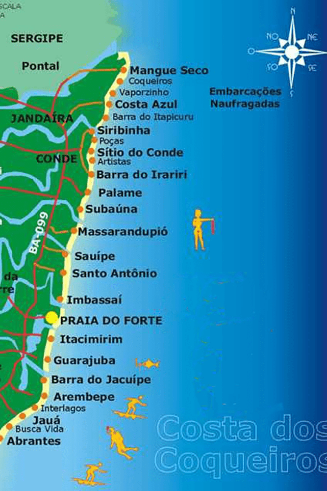
– Costa dos Coqueiros: covers the municipalities on the north coast of Bahia, which offer lush beaches and quality tourist infrastructure.
– Lakes and Canyons of the São Francisco: covers the municipalities in the region of the São Francisco River. It is quite marked by natural beauties such as artificial lakes and canyons carved by the river.
– Salvador and Surroundings: covers the capital of Bahia and neighboring municipalities, which are references in culture, gastronomy and historical heritage.
– São Francisco Valley: covers the municipalities of the middle São Francisco region. They stand out for the production of irrigated fruits and wine tourism.
Source: Setur-Bahia
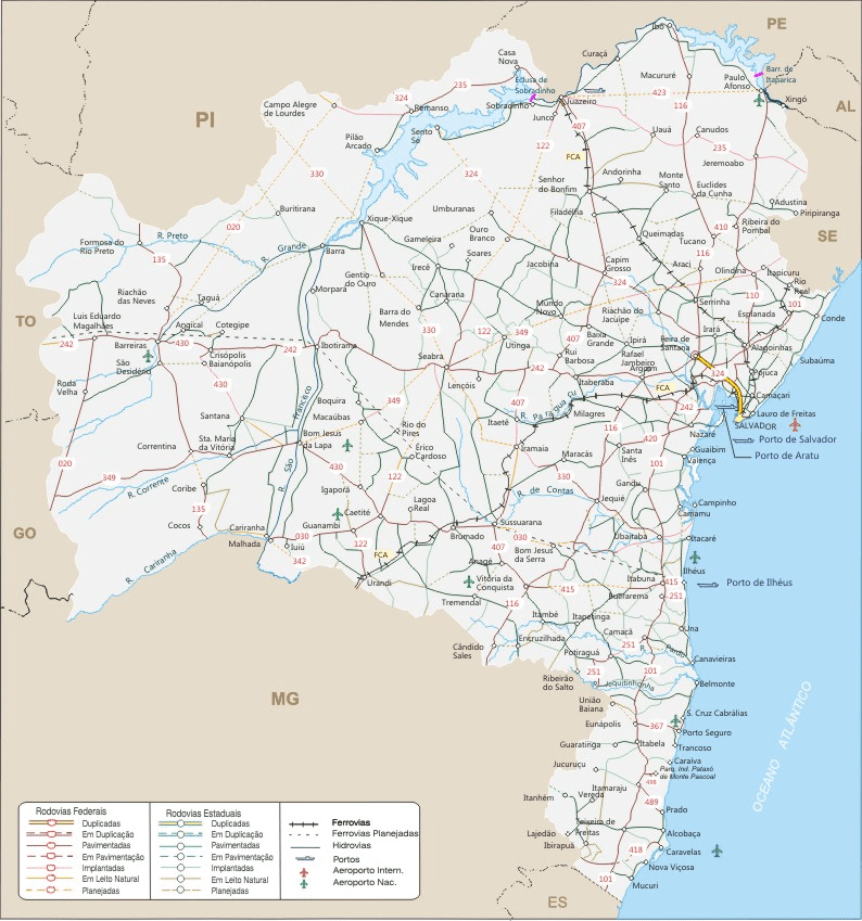
Bahia road map
green line map
Physical map (Complete relief and hydrographic map)
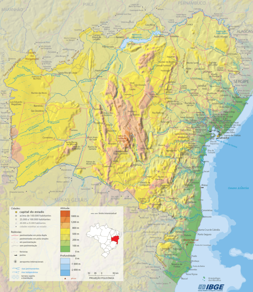
The physical map of Bahia shows the natural characteristics of the state, such as relief, hydrography and climate.
The relief of Bahia is formed by three large units: the Atlantic Plateau, which occupies most of the state and has average altitudes between 300 and 900 meters; the Sertaneja-Sanfranciscana Depression, which extends across the center-north of the state and has altitudes below 500 meters; and the Coastal Plains, which follow the coast and have altitudes below 200 meters.
Bahia's hydrography is made up of three major river basins: the East Northeast Atlantic Basin, which drains the rivers that flow into the Atlantic Ocean in the eastern part of the state; the São Francisco Basin, which drains the São Francisco River and its tributaries in the northern part of the state; and the East Atlantic Basin, which drains the rivers that flow into the Atlantic Ocean in the southern part of the state.
The climate of Bahia is mostly semi-arid tropical, with high temperatures throughout the year and low rainfall. This climate predominates in the interior of Bahia, where there are long periods of drought.
On the coast and in the Atlantic Forest area, the climate is humid tropical. This climate has mild temperatures and rainfall well distributed throughout the year. In the Chapada Diamantina region, the climate is tropical at altitude, with lower temperatures in the higher areas.
Source: IBGE